|
Previous Entry
First Entry
|
What One Can Find Wand'ring in the Fens
 Last weekend, we felt the need to get out of the house. As it was a nice
day, we decided to take a little drive around some of the nearby villages
that we had not yet visited. We've driven past Hilgay many times;
it's along the A10 which is the road we take whenever we are heading south.
Or north, for the most part. It is the major road between Cambridge
and King's Lynn, after all. As I say, we've often driven past Hilgay,
but we had never driven into or through Hilgay, so we thought we'd start
out that way.
We turned off the A10 and meandered through Hilgay, which was pleasant
enough. It's too far away from the rail line and our commute, which is why
we didn't consider it as a place to live. That said, it has most of the
things one wants in a village - some shops on the high street and a pub.
The north end abuts the River Wissey, and has an attractive aspect.
We tootled through town, and then turned to follow a signpost which pointed
toward Southery, the next village along the A10, which we had also never
investigated, for essentially the same reason we had neglected Hilgay.
Southery was also fairly nice. We looked at the houses along the way, commenting
on the features we liked or disliked, admired gardens, and so on. We
didn't feel like getting back on the A10, which we know fairly well, and
so, on a whim, turned left onto Feltwell Road, which led ... somewhere.
Somewhere easterly. We found ourselves on a reasonably large B road,
with fields stretching away in every direction, and the big, Norfolk sky
above us. The next major (in a relative sense) junction, was where the
B1160 turned left, toward Wareham, or one could continue toward Feltwell.
We opted for Wareham, so that might tend northerly.
 Before one reaches Wareham, one passes through Wissington. Wissington,
also on the Wissey, is a sugar plant. West Norfolk grows an awful lot
of sugar beets. These are converted into sugar, proudly market as
British sugar under a variety of brand names. While Wissington was
once a village, it is now nothing more than the largest sugar refinery
in Europe. As one approaches along College Road, the sign 'Beet
Traffic Only' is subtitled in Russian (well, Cyrllic, at least), Croatian,
Latvian, and a couple of other languages that I can't identify. Unlike
Hilgay and Southery, Wissington has little to recommend it. Although there
does seem to be a little park or fishing area just to the north of it
which looked nice enough.
Continuing on our way, we saw a sign for West Dereham. That was
a name which I recognized as being somewhat in a homeward direction,
so we turned on to the West Dereham Road to begin our return journey.
West Dereham Road turned into Wareham Road as we approached West Dereham,
following the old naming conventions common on English country roads.
West Dereham is rather charming, but a bit limited in amenities.
Small, with a population of less than 500, it has, so far as we could see,
no pub, no Post Office, and essentially no shops. What it has
is lovely houses, often with expensive cars parked in front of them.
And the church.
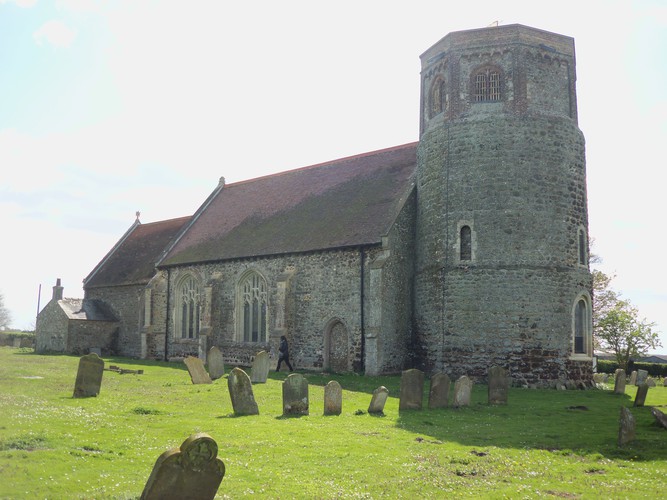
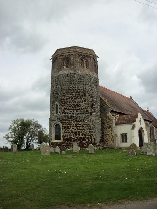
As we were leaving the village, we saw off to one side a strange structure.
It was a church, but with what looked like a watch-tower stuck on the end.
Needless to say, we stopped and went back to have a look. We pulled off the road
behind a car which had disgorged a couple with a some flowers and a battery-powered strimmer, who went into the cemetery across the way to tend to a grave,
presumably that of some departed loved one. We went to examine the church
itself, which is simply fantastic.
It is a Round Tower Church, of which some 180 survive in England, most
in East Anglia, and 124 of which are in Norfolk. They were built primarily between 1000 and 1400, with some having Saxon origins. (Information drawn from
literature provided by the
Round Tower Churches Society.) St Andrew's West Dereham is a Grade I
listed building, whose medieval tower was augmented by a Tudor octagonal
bell tower. The church first appears in the Tax Roll of 1246, but
the church may have been there before that time. The founder of the
Round Tower Churches Society, the late W.J. Goode, speculated
that the tower was built onto an existing church, and that most
round towers were Saxon, with Norman features being added post-Conquest.
Stephen Hart suggests that the tower is late 12th century, with the church
therefore predating it - early 12th or even 11th century.
As one would expect, significant repair and renovation work has been done
over the last 800 or more years. That work has been done for the most
part with great care and sensitivity. Where beams or supports have needed
to be replaced, attempts have been made to match the wood and the style.
The old thatched roof collapsed in 1901, however, and needed to be completely
replaced. The lovely tile roof with the scissor beam supports dates
from that time.
This lovely church is open all the time. This medieval marvel is just sat on
a local road (not even a B road), on the edge of tiny village. There's
not so much as a sign on the nearby A134 to indicate that it's there.
And yet, there it is - free and open to any who know of its existence, or
who, like us, stumble upon it by chance ...
Luddite'sLog, 17 April 2017
© 2016 Jeff Berry
|
Next Entry
Last Entry
|
![Smashy the Hammer hates cell phones [Smashy the Hammer]](/hammer.gif)
![Of course there is mouseover text, because, hey, aspiring. [An Aspiring Luddite]](/Luddite2.gif)
![I am looking at my off-camera
bass guitar [Jeff Berry]](/file.jpg)

