|
Previous Entry
First Entry
|
The Christmas Flood of 2015
 I heard on BBC Radio York that the flooding this year did not surpass the
historic flood of 2000. It fell 20 cm short, about 8 in. Now, eight inches can
be quite a bit when talking about flood heights, and I'm glad we didn't get
that extra eight inches. We don't live in York itself, which was very hard
hit; we live in Strensall, a village a bit to the north of York. Strensall
is on the river Foss, which joins the Ouse just east of
Clifford's Tower.
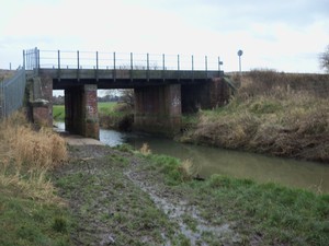
The Foss, at its usual level, looks much like the first picture to the right.
A fairly narrow river, perhaps 12 feet across in that picture, only a few feet
deep, placid and slow moving. At one point it was navigable by canal boat to
a point a number of miles upstream of us. When the barge traffic faded away,
the course of the Foss was modified, its bed altered, and it became
the gentle river which is the only Foss I have ever known.
Until now.
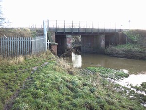
The second picture was taken on Sunday the 27th of December, the day before the
high water mark in York. The water is about six feet higher and eight to
ten feet broader. Look at the left side, where a path is visible in the
first picture and not in the second. Another foot or two, and the river would
be onto the plain off to the left, where we live.

The Foss, usually a mere trickle
where we are, is joined by a variety of becks and streams as it travels the
six or so miles to its confluence with the Ouse, by which time it has become
quite a respectable river. If it starts out as a respectable river, then
the water which it is dumping into the Ouse becomes a significant contributory
factor to the flooding. Or, alternatively, something else happens.
The Foss Barrier was built in 1987 across the river near Castle Mills,
near where
it joins the Ouse. Its purpose is to prevent the Ouse, in flood, from
forcing water back up into the Foss. When closed, it is, essentially, a dam
across the Foss. Now, students of history remember that William the
Conqueror did just that to create the King's Fishpond. Anyone who has
visited York and walks the walls will remember the stretch of the wall walk
which has no walls, because the King's Fishpond provided the defense along
that stretch. To prevent that King's Fishpond from being recreated and
flooding the shopping which now occupies the area known as Foss Islands,
pumps push water over the barrier into the Ouse.
Now, here's the problem. If the pump station floods, two things happen.
First, the barrier is stuck in whatever position it happens to be in.
Second, the pumps fail. It would take something pretty dramatic to flood
the station, though. Something like this year's flood, for instance.
And if the barrier is down, then there is no good way to prevent the King's
Fishpond from reforming. So the barrier was opened, and something in the
neighborhood of six-hundred homes and business theoretically protected by the
barrier were flooded. Not only did the water from the swollen Foss near us
hit them, but water from the swollen Ouse could also back up the channel.
 There is good news. This last picture was taken on Tuesday the 29th. You
can see the water level has dropped by several feet. So a lot of water is not
being dumped into the middle of York. On the other hand, storm Frank hits
today ...
Luddite'sLog, 30 December 2015
© 2015 Jeff Berry
|
Next Entry
Last Entry
|
![Smashy the Hammer hates cell phones [Smashy the Hammer]](/hammer.gif)
![Of course there is mouseover text, because, hey, aspiring. [An Aspiring Luddite]](/Luddite2.gif)
![I am looking at my off-camera
bass guitar [Jeff Berry]](/file.jpg)
 I heard on BBC Radio York that the flooding this year did not surpass the
historic flood of 2000. It fell 20 cm short, about 8 in. Now, eight inches can
be quite a bit when talking about flood heights, and I'm glad we didn't get
that extra eight inches. We don't live in York itself, which was very hard
hit; we live in Strensall, a village a bit to the north of York. Strensall
is on the river Foss, which joins the Ouse just east of

 There is good news. This last picture was taken on Tuesday the 29th. You
can see the water level has dropped by several feet. So a lot of water is not
being dumped into the middle of York. On the other hand, storm Frank hits
today ...